Down Tor Stone Circle Down Tor Stone Circle is a stone circle near Down Tor, Dartmoor. Also called Hingston Hill Cairn. Foggintor Quarry is not far to the northwest, where the stones could have been quarried, along with Down Tor, which is currently a national park. Crazywell Cross is to the north and Drizzlecombe to the south. Coordinates 50.506060,-3.994103 Description Down Tor Stone Circle consists of a long stone row with a circle of stones at the end towards the southwest. This can be considered similar to Drizzlecombe in shape and construction, and is 2 kilometers away. Measurements This tor and circle are angled at 22° towards the southwest, with the row at a length of 755 feet or 230 metres. Analysis It is possible that Down Tor Stone Circle is similar to Drizzlecombe, which was shown to be possibly connected with the golden ratio and π or 9πφ together. The circle is 40 meters wide. If using the 22° on the circle towards the northwest, then all stones pair...
Tikal Temples
Tikal Temples are a group of major structures at Tikal. This is one of the largest cities and archaeological sites of the pre-Columbian Maya civilization. It is located in the Petén Basin region of northern Guatemala.
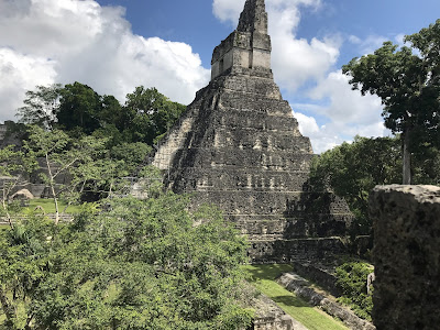
Tikal Temple I on the site is also known as the Temple of the Great Jaguar. It is a typically Petén-styled limestone stepped pyramid structure that is dated to approximately 732 ad.
Coordinates
17.221118,-89.625168
On site, there are the following buildings Mundo Perdido or The Lost World, Seven Temples, Palacio de las Acanaladuras, and North Acropolis, Tikal.
The temples are numbered up to 5 as
Temple of the Great Jaguar (temple 1),
Temple of the Masks (temple 2)
Tikal Temple III (temple 3),
Templo de la Sepiente Bicefala (temple 4) and
Tikal Temple V (temple 5).
Temple angles and separation distances
Temple I is at 3°
Temple II is at 12° and 255 ft
Temple III is at 15° and 500 ft
Temple IV is at 8° and 1200 ft
Temple V is at 7° and 2480 ft
Description
Temple I - 9 layers
Temple II - 3 layers (directly opposite Temple I)
Temple III - 10 layers
Temple IV - 6 layers
Temple V - 6 layers
From the temple angles and separation distances and description above, it can be shown that they connect together by their angle multipled by the layers multipled by distance in feet.
Temple I would just be 3×9=27 but Temple II would be 12×3=36 then 36×255=9180.
Temple I
3×9=27
Temple II
12×3=36
36×255=9180
9180÷3600=2.55
Temple III
15×10=150
150×500=75000
75000÷3600=20.83
Temple IV
8×6=48
48×1200=57600
57600÷3600=16
Temple V
7×6=42
42×2480=104160
104160÷3600=28.93
After applying for each, it shows that Temple III and V could be connected via Major Standstill with a difference of 100 or 1860 years. Dividing this by Temple II gives 729 and divided again gives 27.
Major Standstill
28.93-28.725=0.2083
1860÷2.55=729.4
729÷27=27
This could suggest Temple I is '1', and this also leaves Temple IV.
If using 729 as a year for construction, the angle would be 1.12995°, if this is multipled by 16 and subtracted from the Minor Standstill a number 0.055 is produced. For it to be zero and equal modern day Minor Standstill of 18.134° then the year would be 731 ad as a construction date.
729÷1000=0.729
0.729×1.55=1.12995°
16×1.12995=18.0792
18.0792−18.134=0.055
Conclusion
It shows from above that each major temple is connected to another one. The connection is angle/layers/distance/3600. The use of 3600 shows that they used 24 hrs in a day as 3600 is one hour. They didn't use Mayan base 20 as that would be 4320 seconds. The use of a Major/Minor Standstill shows there are similarities as this is a main feature of other Mesoamerica sites but also shows that base 20 unique to the Mayans was not used, a possibility exists that 3600 was 10 times 360 and not seconds in an hour.
There is no real pattern to the overall site, but as the main temples require accurate separation distances, then all other buildings were built incorporating these factors.
Tikal Temple I
Archeology77 ©

Comments
Post a Comment