Tomb of Ramesses IV The pharaoh Ramesses IV was buried in Tomb KV2, located in the Valley of the Kings, Egypt. The tombs of Ramesses II and VII are on either side. Ramesses died at the age of 27 in 1148 BC. He is connected to the Temple of Khonsu at Karnak. Coordinates 25.741530,32.602080 Description The tomb is of similar design to others in that it has a corridor to the burial chamber with side rooms. It is thought to be about 75 metres long and declines about 10 metres from the entrance. Chamber E, as the antechamber, has stars painted on the ceiling. Chamber K is built with side rooms, and the burial chamber J has a vaulted ceiling with astrological patterns along with the sarcophagus. Coptic monks were said to have lived in the tomb, and in the 19th century, explorers like Jean-François Champollion had camped there. Earlier, Romans were said to have left what is considered as graffiti in the tomb. Measurements These are the tombs' measurements in metres, including the a...
Khafre's Pyramid φ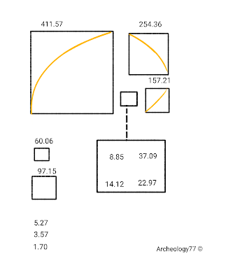
Using the following numbers in cubits gives a ratio of base to height:
Measurements
The volume of a building, or in particular its base or perimeter, was important; this was probably because they were connecting their buildings. Here, Khafre's pyramid is also connected to the Sphinx.
φ
A possible φ marker as it might have appeared on the east face of Khafre's pyramid.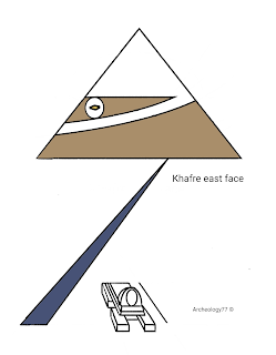
Conclusion
There are two possibilities: one, that during construction, they decided to downscale Menkaure's pyramid in order to include the cubit, which in turn defines the separation distance and thus the error of 24.3 metres. This would then connect to the already built Sphinx, which might have been built in 2773 BC.
Or two, they thought of building the Sphinx as a plan for the entire site, hence intentionally building the Sphinx at a 0.349°/0.377° offset. This then suggests that the Sphinx wasn't built in or about 2773 BC but shortly after the Red Pyramid.
The date 2773 BC minus 243 years is very near to 7°. It has been shown that the earlier pyramids are connected to whole numbers of angles, even though they were built at the same time. There has also been a connection of builds that could possibly involve backdating, which would imply heritage.
Archeology77 ©

Khafre's pyramid is the middle pyramid of the three at Giza. The Giza pyramids were built in the 25th/26th century BC. There is a direct connection between their ratios and the distances and angles of the earlier pyramids, which were built shortly before. A direct connection exists between the 'speed of light' and Khufu's pyramid to the other builds and the Orion constellation.
Analysis
Analysis
Sometimes in construction, it was decided to include the golden ratio, so connecting all three pyramid corners inside an ellipse. A further ellipse was found to connect all three pyramid peaks by a golden ratio that could be measured from Khafre's pyramid's east face, reducing to a distance of 111.27 by 60.06 cubits.
Using the following numbers in cubits gives a ratio of base to height:
Perimeter 1646.2715 ÷ 274.3785 = 6.00
Using the φ towards the east reduces to a cube 8.85 cubits wide, 111.27 cubits (up from the lower right corner), by 60.06 cubits out towards the east.
Measurements
The following calculations connect these to a date; this is about the construction of Menkaure's pyramid.
360 ÷ 60.06 = 6.0
111.27 = km/° latitude
360 ÷ (60.06 − 8.85) = 7.02987°
(2516 BC)
360 ÷ (111.27 − 60.06) = 7.02987°
(2516 BC)
(This is not a 30°/60° triangle, but multiplying the angles in radians equates to 0.532.)
This can apply to any corner on the Khafre pyramid. (The φ rounded to 1.618)
The error from Khufu's pyramid is built into Khafre's pyramid. This is via slope angles or angle offset.)
The volume of a building, or in particular its base or perimeter, was important; this was probably because they were connecting their buildings. Here, Khafre's pyramid is also connected to the Sphinx.
411.57 × 722.13 ÷ 107.155° = 2773
(Pyramid side multiplied by separation divided by angle)
The 2773 was probably there to suggest a year of 2773 BC, which is from the Sphinx's two offset angles from maximum tilt of 0.349° and 0.377°. 0.377° is equal to 243 years rotation, which connects to 24.3 m. The pyramid offset distance added to 1985 gives the year 2227 AD. This suggests that during construction, the best-fit scaling size involved 24.3 m, which could connect to the Sphinx but also shows that the Sphinx was already built. This scaling gave the connecting ellipse that joined all three pyramids to the golden ratio.
Ratio
The 2773 was probably there to suggest a year of 2773 BC, which is from the Sphinx's two offset angles from maximum tilt of 0.349° and 0.377°. 0.377° is equal to 243 years rotation, which connects to 24.3 m. The pyramid offset distance added to 1985 gives the year 2227 AD. This suggests that during construction, the best-fit scaling size involved 24.3 m, which could connect to the Sphinx but also shows that the Sphinx was already built. This scaling gave the connecting ellipse that joined all three pyramids to the golden ratio.
Ratio
All pyramids are linked by the ratio of their heights multiplied by the cubit.
Total heights × royal cubit - 200 = (((125+276+274)×0.523)-200)
This number also gives the separation distance, and hence, 24.3m. Menkaure's pyramid gives the final number, and as the pyramids are rotated 180°, they give the two different lengths for Menkaure's pyramid sides.
φ
The golden ratio's horizon aligns with the φ center by Khafre's pyramid. From here, an ellipse that fits all pyramid peaks gives a radius of 2227 cubits.
The ellipse appears to be a scaling factor and is linked via the φ (this, though, assumes that it was added later, and there wasn't a plan of the entire site. The radius connects with the date and angle, but foremost, it is the constellation of Orion that governs the build).
From here, whole numbers are used linking construction sites.
A possible φ marker as it might have appeared on the east face of Khafre's pyramid.

Conclusion
There are two possibilities: one, that during construction, they decided to downscale Menkaure's pyramid in order to include the cubit, which in turn defines the separation distance and thus the error of 24.3 metres. This would then connect to the already built Sphinx, which might have been built in 2773 BC.
Or two, they thought of building the Sphinx as a plan for the entire site, hence intentionally building the Sphinx at a 0.349°/0.377° offset. This then suggests that the Sphinx wasn't built in or about 2773 BC but shortly after the Red Pyramid.
By doing this, a plan was available for current and future builders. Scaling also allowed for the elliptic, which is 243 years past its peak. This was important, as the separation angle plus the cubit gives 2046 past the peak (this is also near Khufu's pyramid chamber volume).
The year 2046, being 0.05° plus one planet rotation after 1985, also connects to Wety's tomb at the Saqqara pyramid complex near Cairo. Wety was a priest from 2450 BC (20 km away at Djoser).
Describing his tomb's size with an equation:
(0.523⁴) × 100 × (20 × 0.523) or
(0.523⁴) × 1046
(0.523⁵) × 1046 × 1.912
(0.523¹⁰) × 1046 × 1.912⁶
(0.523⁶) × 10⁵ = 2046
(2046 is the year of a cubit alignment. This increases the equation of the tomb's ratio so that it goes up in powers while still being equal to the volume (to three decimal places).
The date 2773 BC minus 243 years is very near to 7°. It has been shown that the earlier pyramids are connected to whole numbers of angles, even though they were built at the same time. There has also been a connection of builds that could possibly involve backdating, which would imply heritage.
Archeology77 ©
Comments
Post a Comment