Tomb of Ramesses IV The pharaoh Ramesses IV was buried in Tomb KV2, located in the Valley of the Kings, Egypt. The tombs of Ramesses II and VII are on either side. Ramesses died at the age of 27 in 1148 BC. He is connected to the Temple of Khonsu at Karnak. Coordinates 25.741530,32.602080 Description The tomb is of similar design to others in that it has a corridor to the burial chamber with side rooms. It is thought to be about 75 metres long and declines about 10 metres from the entrance. Chamber E, as the antechamber, has stars painted on the ceiling. Chamber K is built with side rooms, and the burial chamber J has a vaulted ceiling with astrological patterns along with the sarcophagus. Coptic monks were said to have lived in the tomb, and in the 19th century, explorers like Jean-François Champollion had camped there. Earlier, Romans were said to have left what is considered as graffiti in the tomb. Measurements These are the tombs' measurements in metres, including the a...
Drombeg Stone Circle
Marker stars

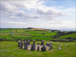
Drombeg Stone Circle, also known as The Druid's Altar, is a stone circle near Glandore, County Cork, Ireland.
There are actually three circular structures and multiple individual stones on site.
Representation
This is most probably a representation of tilt and obliquity designed into a number of stone circles judging by its angle of 36° and thus could date to about 600 bc. They needn't be forward aligned as a path from the third is equal to it's orientation which also happens to be east/west.
Description
Also known as The Druid's Altar, 9.3m across and 36° towards southwest. There are 17 stones in the large circle with 1 lying on its side, an angle of 36° that aligns it towards the horizontal line, and from the double circle, a 2-4° line aligns towards this line.
They intersect about 20m from smaller double to 25m from the larger. An exit from the third structure aligns east/west, it contains two rectangular slots, and the whole area contains multiple partially buried stones as if used for a quarry or erected from this area.
Example
For example, the one by the larger stone circle is also angled at 36° but the angle between them is 2×54°=108°, (there are far too many partially buried stones to ascertain how complex the site is).
Continuing a further stone is 12° (48° away from 36° stone on the side) and another that has an angle of 12-27° (15° wide) from the centre. With the intersection from earlier, their intersect location is near to a double partially buried stone, when a line is drawn using the angle of a path (86°) it goes in between the two stones and through the intersection.
The two stones become clear that they should be in the slots inside the third circle with orientation from there.
They represent a binary star system, and the third circle is a representation of what they appear like, the second a depiction of them. The angles to these stars are 4°-86°=90° apart from marker location (also a star) and 36°, oriented from the horizon, then rotate 36° and become 40° north 50° west.
The largest stone circle becomes the directional rotation of 54+86=140° or if measured from the binary star, the angle would be 108° to Earth.
Constellation
One possibility is 11 Leonis Minoris northern constellation of Leo Minor at 36.2ly away.
Right ascension 09h 35m 39.50181s
Declination +35° 48′ 36.4841″
Because the maker to the binary is 90°, at right ascension 9hrs 35m, then 6hrs earlier is at right ascension 3hrs 35m at 50°.
Description
Also known as The Druid's Altar, 9.3m across and 36° towards southwest. There are 17 stones in the large circle with 1 lying on its side, an angle of 36° that aligns it towards the horizontal line, and from the double circle, a 2-4° line aligns towards this line.
They intersect about 20m from smaller double to 25m from the larger. An exit from the third structure aligns east/west, it contains two rectangular slots, and the whole area contains multiple partially buried stones as if used for a quarry or erected from this area.
Example
For example, the one by the larger stone circle is also angled at 36° but the angle between them is 2×54°=108°, (there are far too many partially buried stones to ascertain how complex the site is).
Continuing a further stone is 12° (48° away from 36° stone on the side) and another that has an angle of 12-27° (15° wide) from the centre. With the intersection from earlier, their intersect location is near to a double partially buried stone, when a line is drawn using the angle of a path (86°) it goes in between the two stones and through the intersection.
The two stones become clear that they should be in the slots inside the third circle with orientation from there.
They represent a binary star system, and the third circle is a representation of what they appear like, the second a depiction of them. The angles to these stars are 4°-86°=90° apart from marker location (also a star) and 36°, oriented from the horizon, then rotate 36° and become 40° north 50° west.
The largest stone circle becomes the directional rotation of 54+86=140° or if measured from the binary star, the angle would be 108° to Earth.
Constellation
One possibility is 11 Leonis Minoris northern constellation of Leo Minor at 36.2ly away.
Right ascension 09h 35m 39.50181s
Declination +35° 48′ 36.4841″
Because the maker to the binary is 90°, at right ascension 9hrs 35m, then 6hrs earlier is at right ascension 3hrs 35m at 50°.
Marker stars
(1)(12.75° off)
θ Persei in the constellation Perseus 37ly away.
Right ascension 02h 44m 11.98704s
Declination +49° 13′ 42.4111″
Right ascension 02h 44m 11.98704s
Declination +49° 13′ 42.4111″
(2)(2.75° off)
Mirfak in the northern constellation of Perseus 510ly away.
Right ascension 03h 24m 19.37009s
Declination +49° 51′ 40.2455″
This doesn't give a time of year, but at 0.5° off suggests obliquity plays a role, and this would equate as 0.5÷0.000117°=4273
4273-2020=2253 bc.
The 15° wide stone suggests 1hr rotation for a 24-hour measurement on 360°. A line of curved stones around the larger stone circle could suggest lunar precession or solar eclipse at 76° north.
Because of the possible stars listed between right accession 2hr/9hrs then a possible link to the Milky Way should be included and one exists at 55° from centre of large stone circle to a line of three stones which are at 55°, 59° and 63°. Also, the structure is quite defined as a binary with planetary matter around it, although this could be dust or gas clouds, and almost certainly a binary star.
The difference of 11 Leonis Minoris from 40° is quite large at 4.2° and can’t be easily explained. It has a rotation of 2720 years, and there could possibly be planetary matter in orbit around it.
Error understanding and correction for the measurements.
The further stars are away from the Sun the bigger the differences are over time.
With 11 Leonis Minoris (36.5) away, the star has been measured at moving away from the Earth with a heliocentric radial velocity of
RA: −726.201 mas/yr
Dec.: −259.506 mas/yr
RA=0.0002017225°/year
Dec=0.000072085°/year
This suggests that it drifts east/west at a rate of 0.2°/1000 years and an inclination change at a rate of 0.07°/1000 years.
With the stone circles, the intersection is no more than 2m from the two stones. The angle of variation is small, but including the 86° path line reduces this further.

For instance 3° from the double circle aligns over the double stones, and 5° misaligned the same but also no longer aligns with the double circle. It can be suggested that the error of variation is the measured angle +- 0.5°, but this is reduced as the gap between the double stones is 0.3m, and the angle to align in the middle is 8.602°. At 90° this angle becomes 8.531° on either side, with an angle of 86° away from the double stones. The angle becomes 8.599°
8.602-8.599=0.003°
0.003° at 2m, the angle has 1 mm of variation. Difference off the stated angles
90°=135.5943-45.40538=90.189°=0.189°
40°=40-35.81013=4.189°
50°=50-49.86118=0.139°
11 Leonis Minoris northern constellation of Leo Minor.
Right ascension 09h 35m 39.50181s
Declination +35° 48′ 36.4841″
Mirfak in the northern constellation of Perseus 510ly away.
Right ascension 03h 24m 19.37009s
Declination +49° 51′ 40.2455″
Other examples of binary stars in Leo Minoris and Leo that are near to the separation angles 90°/40°N/50°W and stars and galaxy in the same constellation that could have an interpretation for the stones.
Beta Leonis Minoris is also a binary at 154ly away.
Right ascension 10h 27m 53.000s
Declination +36° 42′ 25.96″ RA=150.4647222°=105.059° Dec=36.70721°=3.29279°
83 Leonis is also a binary star in the constellation of Leo 59ly away.
Right ascension 11h 26m 45.3217s
Declination +3° 0′ 47.1586″
β Leonis is the second-brightest star in the constellation of Leo 39.5ly away.
Right ascension 11h 49m 03.57834s
Declination +14° 34′ 19.4090″
NGC 3432 is a spiral galaxy that can be found in the constellation Leo Minor.
Right ascension 10h 52m 31.1s
Declination +36° 37′ 08″
Other stones
There are the three stones in a row at equal distances, if a manipulation of the diagram is made so as to align the star 11 Leonis Minoris and Mirfak then the 36° line passes in-between and marks a stone just pass it.
This is an alignment of offsetting the focal point into space marked by the stone and the three stones being just three equalling spaced stars.
Right ascension 03h 24m 19.37009s
Declination +49° 51′ 40.2455″
This doesn't give a time of year, but at 0.5° off suggests obliquity plays a role, and this would equate as 0.5÷0.000117°=4273
4273-2020=2253 bc.
The 15° wide stone suggests 1hr rotation for a 24-hour measurement on 360°. A line of curved stones around the larger stone circle could suggest lunar precession or solar eclipse at 76° north.
Because of the possible stars listed between right accession 2hr/9hrs then a possible link to the Milky Way should be included and one exists at 55° from centre of large stone circle to a line of three stones which are at 55°, 59° and 63°. Also, the structure is quite defined as a binary with planetary matter around it, although this could be dust or gas clouds, and almost certainly a binary star.
The difference of 11 Leonis Minoris from 40° is quite large at 4.2° and can’t be easily explained. It has a rotation of 2720 years, and there could possibly be planetary matter in orbit around it.
Error understanding and correction for the measurements.
The further stars are away from the Sun the bigger the differences are over time.
With 11 Leonis Minoris (36.5) away, the star has been measured at moving away from the Earth with a heliocentric radial velocity of
RA: −726.201 mas/yr
Dec.: −259.506 mas/yr
RA=0.0002017225°/year
Dec=0.000072085°/year
This suggests that it drifts east/west at a rate of 0.2°/1000 years and an inclination change at a rate of 0.07°/1000 years.
With the stone circles, the intersection is no more than 2m from the two stones. The angle of variation is small, but including the 86° path line reduces this further.

For instance 3° from the double circle aligns over the double stones, and 5° misaligned the same but also no longer aligns with the double circle. It can be suggested that the error of variation is the measured angle +- 0.5°, but this is reduced as the gap between the double stones is 0.3m, and the angle to align in the middle is 8.602°. At 90° this angle becomes 8.531° on either side, with an angle of 86° away from the double stones. The angle becomes 8.599°
8.602-8.599=0.003°
0.003° at 2m, the angle has 1 mm of variation. Difference off the stated angles
90°=135.5943-45.40538=90.189°=0.189°
40°=40-35.81013=4.189°
50°=50-49.86118=0.139°
11 Leonis Minoris northern constellation of Leo Minor.
Right ascension 09h 35m 39.50181s
Declination +35° 48′ 36.4841″
Mirfak in the northern constellation of Perseus 510ly away.
Right ascension 03h 24m 19.37009s
Declination +49° 51′ 40.2455″
Other examples of binary stars in Leo Minoris and Leo that are near to the separation angles 90°/40°N/50°W and stars and galaxy in the same constellation that could have an interpretation for the stones.
Beta Leonis Minoris is also a binary at 154ly away.
Right ascension 10h 27m 53.000s
Declination +36° 42′ 25.96″ RA=150.4647222°=105.059° Dec=36.70721°=3.29279°
83 Leonis is also a binary star in the constellation of Leo 59ly away.
Right ascension 11h 26m 45.3217s
Declination +3° 0′ 47.1586″
β Leonis is the second-brightest star in the constellation of Leo 39.5ly away.
Right ascension 11h 49m 03.57834s
Declination +14° 34′ 19.4090″
NGC 3432 is a spiral galaxy that can be found in the constellation Leo Minor.
Right ascension 10h 52m 31.1s
Declination +36° 37′ 08″
Other stones
There are the three stones in a row at equal distances, if a manipulation of the diagram is made so as to align the star 11 Leonis Minoris and Mirfak then the 36° line passes in-between and marks a stone just pass it.
This is an alignment of offsetting the focal point into space marked by the stone and the three stones being just three equalling spaced stars.
The difference of the further examples increases the differences considerably and is best considered as recognisable shapes from the constellations Leo Minoris and Leo.
Other stones may have made these measurements clearer but also may represent stars.
Other stones may have made these measurements clearer but also may represent stars.
The currently measured drift for 11 Leonis Minoris is 0.2 W and 0.07 N.
At east/west
1000 bc =0.6°
2000 bc =0.8°
3000 bc =1.0°
At north
1000 bc =0.22°
2000 bc =0.29°
3000 bc =0.36°
Current coordinates 51.564576,-9.087261 Coordinates in Cornwall 50.140109,-5.094761 Difference 1.424467, 3.9925
Using the east/west and ÷ by the rate/1000 years gives a value of 862 bc.
4.2-3.9925=0.2075÷0.07×1000=862
For this inclination to reach 4.2° it would be about 60000 years also putting the other values off at the same time.
A measurement at a 4° offset location would have helped in measurements, but they might have mixed their numbers by doing so. A 4.2° inclination could be tilt or inclination to Sun's equator again, giving two different numbers.
Conclusion
A group of people would have made measurements in Cornwall and took their ideas to southern Ireland where they built these stones, although the offset into space could explain it.
Whether it is the 3.99° or 1.42° elevation that gives the location, it could just be the 4.2° from where it should be that marks the alignment point. They also used shapes for other stars and galaxy in these constellations as they might have been more memorial, possibly thinking that no one might understand it's purpose.
By having an offset it allowed them to build the stones as they are and giving all the required angles, another possibility could have been to dig a tunnel to reduced the offset, possibly indicated by the sunken pathway. With these in mind, it would have been constructed sometime between 600-862 bc in the Iron Age.
At east/west
1000 bc =0.6°
2000 bc =0.8°
3000 bc =1.0°
At north
1000 bc =0.22°
2000 bc =0.29°
3000 bc =0.36°
Current coordinates 51.564576,-9.087261 Coordinates in Cornwall 50.140109,-5.094761 Difference 1.424467, 3.9925
Using the east/west and ÷ by the rate/1000 years gives a value of 862 bc.
4.2-3.9925=0.2075÷0.07×1000=862
For this inclination to reach 4.2° it would be about 60000 years also putting the other values off at the same time.
A measurement at a 4° offset location would have helped in measurements, but they might have mixed their numbers by doing so. A 4.2° inclination could be tilt or inclination to Sun's equator again, giving two different numbers.
Conclusion
A group of people would have made measurements in Cornwall and took their ideas to southern Ireland where they built these stones, although the offset into space could explain it.
Whether it is the 3.99° or 1.42° elevation that gives the location, it could just be the 4.2° from where it should be that marks the alignment point. They also used shapes for other stars and galaxy in these constellations as they might have been more memorial, possibly thinking that no one might understand it's purpose.
By having an offset it allowed them to build the stones as they are and giving all the required angles, another possibility could have been to dig a tunnel to reduced the offset, possibly indicated by the sunken pathway. With these in mind, it would have been constructed sometime between 600-862 bc in the Iron Age.
(A marker stone may exist, which is part buried and marks a measure point and direction)
Delta Trianguli
Drombeg Stone Circle
Archeology77 ©
Delta Trianguli
Drombeg Stone Circle

Archeology77 ©
Comments
Post a Comment